The Suwałki Gap: NATO's narrowest and most exposed corridor
The Suwałki Gap is the stretch of Polish–Lithuanian border country wedged between Russia's Kaliningrad exclave to the west and Belarus to the east — about 65 km across in a straight line, with some 104 km of border between the two ends. It is the only land connection between Estonia, Latvia and Lithuania and the rest of NATO. Cut it, and three member states are reachable only by sea and air. It is also called the Suwałki corridor (Polish przesmyk suwalski, Lithuanian Suvalkų koridorius, Russian Сувалкский коридор, German Suwalki-Lücke).
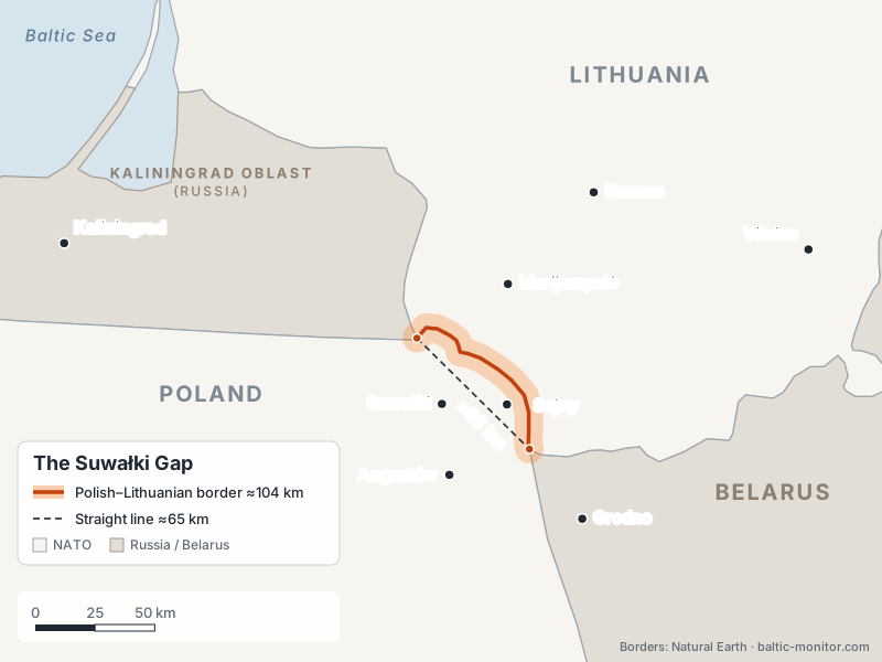
The corridor: about 104 km of Polish–Lithuanian border (orange) between the Kaliningrad and Belarus tripoints, which are about 65 km apart in a straight line.
That single fact has made the corridor the most-modelled piece of ground in European defence planning — and one of the most-searched. This page sets out what the gap actually is, who defends it, what changed in 2026, and what the daily monitoring has and has not recorded there.
What is the Suwałki Gap?
The Suwałki Gap is the land corridor along the Polish–Lithuanian border that separates Russia's Kaliningrad oblast from Belarus. It is named after Suwałki, the main town on the Polish side. For NATO it is the only overland route between Poland and the three Baltic states; for Russia it is the strip of NATO territory between its exclave and its ally Belarus.
How wide is the Suwałki Gap?
About 65 km in a straight line — the distance between the point where the borders of Poland, Lithuania and Russia meet and the point where Poland, Lithuania and Belarus meet. The Polish–Lithuanian border that links those two points is about 104 km long, because it follows a winding course (Defence24; Wikipedia). That is why figures between 65 and 100 km circulate: the first is the straight-line gap, the second the length of border that would have to be held.
Where is the Suwałki Gap on the map?
In north-eastern Poland and south-western Lithuania, between the Polish towns of Suwałki, Sejny and Augustów and the Lithuanian town of Marijampolė. Its north-western end is the tripoint with Kaliningrad oblast near Lake Vištytis (Polish Jezioro Wisztynieckie); its south-eastern end is the tripoint with Belarus, north-west of the Belarusian city of Grodno. The Via Baltica road crosses the corridor between Suwałki and Marijampolė on its way to Kaunas.
Is the Suwałki corridor closed right now?
No. Through the period covered by this monitor — daily issues since 3 June 2026 — the corridor has remained open to normal road and rail traffic, and no issue has recorded a military closure or blockade of it.
The question is asked often because the corridor is the subject of recurring rumour waves, and because genuine disruptions do happen nearby without touching the corridor itself: Lithuania has closed border crossings with Belarus and briefly shut Vilnius and Kaunas airports over smuggling balloons drifting in from Belarusian territory, and Russia has suspended traffic through several railway crossings on its own borders. None of these is a closure of the Suwałki Gap.
For the current picture, the daily issues linked at the bottom of this page are the primary record.
Why the corridor is a weak point
Three things make the gap militarily awkward for NATO.
It is narrow and flanked from both sides. An advance from Kaliningrad in the west and from Belarus in the east has less than 100 km to cover to meet in the middle. The terrain — forest, lakes and a thin road network — favours whoever moves first and constrains a defender trying to shuttle reinforcements north.
It carries everything. The Via Baltica motorway, the Rail Baltica railway and the Harmony Link power interconnector all thread through the same corridor. Military mobility, civilian supply and the Baltic power system share one route.
Both sides are vulnerable in the same place. The corridor is NATO's land bridge to the Baltics; Kaliningrad is Russia's exclave, supplied by sea and by transit across Lithuania. Each side's contingency plan looks, from the other side, like preparation for the attack it fears. That symmetry is why the area is treated as one of Europe's main escalation triggers rather than simply as a defensive problem.
How the corridor is defended
Poland is the region's largest military power, spending roughly 4.7% of GDP, with an army that has grown from about 89,000 to 216,000 personnel since 2014. Its East Shield programme (Tarcza Wschód, ~$2.5bn) is building some 700 km of fortifications, bunkers, surveillance and counter-drone systems along the borders with Kaliningrad and Belarus. German engineering units have been assisting since April 2026.
A NATO multinational battlegroup sits immediately south of the gap at Bemowo Piskie, with the United States as framework nation — M1A2 Abrams tanks and Bradley infantry fighting vehicles, alongside British, Romanian and Croatian contingents — integrated with Poland's 15th Mechanised Brigade.
Lithuania is thickening the northern shoulder. The Seimas has approved a military training ground near the corridor (Kapčiamiestis), with exercises expected from 2028 and firing ranges by 2030. Lithuanian engineers have prepared border bridges for demolition. And north of the gap, Germany's 45th Armoured Brigade (Panzerbrigade 45 "Litauen", Rūdninkai and Rukla) is standing up toward full operational readiness in 2027 at roughly 4,800 troops — the Bundeswehr's first permanently stationed brigade abroad.
Allied exercises are now held deliberately in and around the gap. In June 2026 the multinational exercise Gallant Boar 2026 — Lithuanian Drąsusis šernas, reported by some outlets as "Brave Boar" — ran from 16 to 26 June with Lithuanian, Polish and French participation, working the corridor scenario directly.
What the 2026 monitoring actually recorded
Two patterns stand out across the daily issues.
The first is that the pressure at the corridor in 2026 has been hybrid rather than kinetic. The recurring entries are instrumentalised migration on the Latvia–Belarus border, including smuggling tunnels that Latvia's Border Guard chief said Belarusian authorities were complicit in building, and balloons launched from Belarusian territory that have forced Lithuanian airport closures. Lithuania has declared its readiness to shoot such balloons down. Counter-smuggling operations such as Vilkatis ran through August.
The second is what did not happen. No large Russian-Belarusian exercise was announced near the corridor for autumn 2026. The strategic "Zapad" series is quadrennial; the last iteration was Zapad-2025 in September 2025 and the next is expected around 2029. Searches for a "Zapad 2026" are looking for an exercise that was never scheduled — see the Zapad 2026 page.
The build-up in the corridor area during 2026 has therefore been overwhelmingly on the NATO side: the German brigade to the north, the American-led battlegroup to the south, new Lithuanian ranges, and allied exercises held in the gap itself. In this monitor's daily assessment these register as defensive up-factors — they raise military density in a sensitive place, which is a stabiliser against a fait accompli and an escalation risk at the same time.
The Russian view
Moscow treats NATO activity around the corridor as a threat to its land access to Kaliningrad and has repeatedly stated that any attempt to blockade the exclave would draw a military response. Russian commentary frames the Lithuanian ranges, the German brigade and the corridor exercises as rehearsal for cutting Kaliningrad off rather than as protection of the Baltic land bridge.
Both readings describe the same forces. That is the corridor's defining problem: there is no posture either side can adopt here that the other reads as purely defensive.
Frequently asked questions
How wide is the Suwałki Gap?
About 65 km in a straight line between the Kaliningrad and Belarus borders. The Polish–Lithuanian border between those two points is about 104 km long, which is why figures of up to 100 km are also quoted.
Which towns are in the Suwałki Gap?
On the Polish side the main towns are Suwałki, Sejny and Augustów; on the Lithuanian side the nearest larger town is Marijampolė, with Lazdijai and Kalvarija close to the border. Kaunas lies roughly 100 km to the north-east.
Which countries border the Suwałki corridor?
Poland and Lithuania hold the corridor itself. Russia's Kaliningrad region lies to the west of it and Belarus to the east.
Has the Suwałki corridor ever been closed?
Not in the period this monitor covers. Nearby border crossings with Belarus and Lithuanian airports have been closed temporarily for hybrid-threat reasons, but the corridor itself has stayed open to road and rail traffic.
Why is the Suwałki Gap so important to NATO?
It is the only land route by which NATO can reinforce Estonia, Latvia and Lithuania. Without it, reinforcement depends on the Baltic Sea and on air transport, both of which are within reach of Kaliningrad-based systems.
Is NATO reinforcing the corridor?
Yes. Poland's East Shield fortifications, the US-framework battlegroup at Bemowo Piskie, Germany's 45th Armoured Brigade in Lithuania, new Lithuanian training grounds near the gap and exercises such as Gallant Boar 2026 all concentrate on the corridor and its approaches.
Sources
- Suwałki Gap — Wikipedia
- Lithuania–Poland border — Wikipedia
- Tarcza Wschód także na granicy z Litwą — Defence24
- Lithuanian parliament approves military training ground in Suwałki gap — LRT
- Lithuania, Poland to step up military cooperation, hold joint exercises in Suwałki Gap — LRT
- NATO troops drill near Suwałki Gap as Poland hosts Gallant Boar 2026 — TVP World
- How Poland and Lithuania Are Defending the Suwalki Corridor — The National Interest
This page is maintained alongside the daily digests; the list of related issues above updates automatically.